Ribiera Sacra
Introduction
They call the north west of Spain "Green Spain". It rains a lot
and it is indeed very green and fertile.
The two geographical features that influence the climate of this corner of Spain are the Cordillera Cantabrica and the proximity of the Atlantic Ocean. The Cordillera is a massive chain of mountains, running about 300 km across the north of Spain, almost parallel to the Bay of Biscay. It also extends to the south-west as the Sierra de Ancares which forms the boundary between Galicia and Léon.
Winds from the Bay of Biscay and the Atlantic bring rain to the coast, to the mountain slopes and to the hilly lands between the coast and the mountains. The coastline is windy and rugged, along the Galician shores characterised either by rocky cliffs or a series of rias, submerged valleys where the sea extends many kilometres inland.
Much of the good walking is in the mountain areas. The
dramatic coast and adjacent countryside are also accessible
by a range of routes, either the limited number of long distance
trails that cross the area or many local shorter sendieros.
We have visited this area twice. The first time was in the early summer of 2003 after our circuit of northern Portugal when we came, at last, to Santiago de Compostella and then briefly explored the Picos de Europa. It rained a lot but we loved the area so much that we asked the locals when we should visit to find more reliable weather. They said to come in September, so we did - the very next year.
Starting and ending in Bilbao, our route in 2004 was an anti clockwise loop, first along the coast then inland to the mountains, exploring the relatively unknown Ancares and Somiedo national parks and finally spending two weeks in the Picos de Europa. It only rained a bit.
Bilbao and Gernika
You go to Bilbao, in the Basque country, because because it is an easy
entry point to northern Spain and because of the Guggenheim Museum.
The Casco Viejo, or old town, is less well known than the Guggenheim
but is lively with restaurants, bars and shops and is well located on the
Norman Foster designed metro. It is a good place to stay.
The Frank Gehry designed Guggenheim Museum was opened in 1997 and has drawn hosts of visitors ever since. It is a fantastic structure of titanium and glass, designed to resemble fish scales. Inside, light pours into the lofty spaces which can accommodate very grand scale exhibits. The permanent exhibits do not have the drawcards found in the world's major museums but there are always interesting temporary exhibitions and we were lucky enough to discover a major exhibition of Alexander Caldor's fascinating mobiles.
The Frank Gehry designed Guggenheim Museum was opened in 1997 and has drawn hosts of visitors ever since. It is a fantastic structure of titanium and glass, designed to resemble fish scales. Inside, light pours into the lofty spaces which can accommodate very grand scale exhibits. The permanent exhibits do not have the drawcards found in the world's major museums but there are always interesting temporary exhibitions and we were lucky enough to discover a major exhibition of Alexander Caldor's fascinating mobiles.
A short train trip from
Bilbao is Gernika, grimly
remembered because of
the bombing of the city
in 1937. It is a quiet
place today, going about
its business without a
great deal of interest
from outside. An
excellent little museum
has many photos and
Gernika
models and a very moving film is shown, simulating the nightmarish events of the day
when German planes dropped bombs on a crowded market place. In the town itself
there is a full size mosaic of Picasso's great painting.
Galicia - Santiago de Compostella
and the Coast
Santiago de Compostella
In Galicia, the pilgrim routes coming from all directions converge on Santiago de
Compostella. The pilgrimage to Santiago, el camino, has become an amazing
phenomen with the number of pilgrims reaching the Cathedral of Santiago growing
enormously over the years. The peak was reached in 2010, a holy year, when 272,135
pilgrims received their certificado. The following year 2011, there was some respite with
only 183,366 arriving. In 1988, when we did our stage between Le Puy and Conques in
France (link) only 3,501 completed the journey. It has become a craze, a symbol of "self
discovery", almost a cult, but most of all a huge business.
We have visited Santiago twice and somewhat defiantly, never arrived on foot. The first time we came by train from Portugal and the second time drove our hire car into the enormous car park that has been excavated under the town. Notwithstanding the number of visitors, Santiago is a charming and agreeable town - or at least it was when we visited before the extraordinary increase in pilgrims. The historic centre is a maze of narrow pedestrianised streets, colonnaded buildings lining the streets are of dark stone with white window frames and trimmings and under the colonnades are little shops selling souvenirs to commemorate the pilgrims' arrival. This has probably not changed over the centuries. A unique feature that we loved was the diversity of lead drainpipes decorated with pretty designs and curious little people.
We have visited Santiago twice and somewhat defiantly, never arrived on foot. The first time we came by train from Portugal and the second time drove our hire car into the enormous car park that has been excavated under the town. Notwithstanding the number of visitors, Santiago is a charming and agreeable town - or at least it was when we visited before the extraordinary increase in pilgrims. The historic centre is a maze of narrow pedestrianised streets, colonnaded buildings lining the streets are of dark stone with white window frames and trimmings and under the colonnades are little shops selling souvenirs to commemorate the pilgrims' arrival. This has probably not changed over the centuries. A unique feature that we loved was the diversity of lead drainpipes decorated with pretty designs and curious little people.
There are many good restaurants
with a fantastic range of tapas
and raciones which were a joy to
us after the heavy food of
Portugal. Among the souvenir
shops are jewellery shops which
sell quite elegant jewellery made
from silver and jet - a tasteful
souvenir of Santiago which may
be preferred to cockle shells.
But of course, we have all come
here to see the cathedral which
reveals itself almost by chance.
Out of the narrow streets of the
town you suddenly emerge into the enormous Praza do Obradoiro to be confronted by one
of the most elaborate Baroque facades in Christendom. It was undoubtedly a lot simpler at
the time of its construction between 1075 and 1211 but now it goes for the full-on baroque
WOW factor.
The pilgrims arrive in the Praza in jubilation and tearful exhaustion. It is very emotional to be there to see the arrivals - on foot or bicycle - and to reflect that this scene has played out for ten centuries or more.
The pilgrims arrive in the Praza in jubilation and tearful exhaustion. It is very emotional to be there to see the arrivals - on foot or bicycle - and to reflect that this scene has played out for ten centuries or more.
La Costa da Morte
For many pilgrims the journey continues to Cabo Fisterra, Finisterre in English, a rocky
peninsula 90 km from Santiago, and almost the westernmost point of the Iberian
Peninsula. Those that continue to the cabo burn their clothes or boots there to mark the
very end of the pilgrimage. The origin of this recent tradition is unclear.
Fisterra enjoys a kind of mythical status as being at the "edge of the world". The name Fisterra comes from Latin 'finis terrae', literally 'end of land'. Mistranslations like 'the end of the earth' or 'the end of the world' contribute to the mythology. Cap Finisterre in Brittany and Landsend in Cornwall are similar 'ends of the world'.
Fisterra enjoys a kind of mythical status as being at the "edge of the world". The name Fisterra comes from Latin 'finis terrae', literally 'end of land'. Mistranslations like 'the end of the earth' or 'the end of the world' contribute to the mythology. Cap Finisterre in Brittany and Landsend in Cornwall are similar 'ends of the world'.
The suggestion of menace carries
on with the naming of the nearby
coast as La Costa da Morte, the
'coast of death'. An explanation of
this name asserts it comes from
the pagan belief that, as the sun
disappeared each day into the
sea, it sank into the land of the dead until the following morning when it rose again into the
land of the living.
An alternative theory asserts more realistically that the name relates to the many shipwrecks
that have occurred along this treacherous rocky stretch of shore.
We based ourselves for a couple of days in the small fishing town of Camariñas to walk and
explore the coast. This little town spreads out from its port where colourful fishing boats are
moored. White and pastel coloured buildings have red tiled roofs, pretty in the soft mist that
often settles on the town. Fishing in the ocean and collection of sea urchins and shellfish on
the tidal flats are the base of the economy. Lace making is also an important cottage industry
here.
We found an agreeable pathway that followed the
coast, traversing green hillsides above the rocky
crags that drop down to pebbly beaches,
occasionally a sandy one. There are lighthouses
along these cliffs but, experiencing the misty
atmosphere, we could well imagine the troubles
of shipping in stormy weather.
Indeed in November 2002 the oil tanker 'Prestige' sank and broke up off this coast, causing a spill that polluted thousands of kilometers of coastline and more than one thousand beaches on the Spanish, French and Portuguese coasts. It also caused enormous harm to the fishing industry.
Indeed in November 2002 the oil tanker 'Prestige' sank and broke up off this coast, causing a spill that polluted thousands of kilometers of coastline and more than one thousand beaches on the Spanish, French and Portuguese coasts. It also caused enormous harm to the fishing industry.
The spill was the largest environmental disaster in the history of both Spain and Portugal and has taken
years to remedy.
As we walked along the coastal pathway we came upon a group of workers engaged in the cleanup. Only now, in 2012, is there some confidence that the cleanup has been successfully completed, but there are still reports of small spills from the wreck.
As testimony to the strong winds, or perhaps to Spain's commitment to renewable energy, there were lines of windmills on every hill. Our walk took us in a loop back to town past an anchovy factory, an aromatic reminder of the local industry. We ate wonderful sea food in Camariñas.
On either side of the Costa da Morte are the Rias Bajas and
the Rias Altas. The Rias Bajas is a series of beautiful
estuaries that extend down towards the Portuguese border.
There are long distance walking trails through this area and
also many short routes, particularly around the town of Vigo.
In the village is a little granite chapel consecrated to Saint Andrew and, so they
say, keeping his bones. Every year on 8 September it is the focus of a pilgrimage
but throughout the year there are many visitors buying tacky souvenirs from the
many stalls that line the streets.
According to another legend it is said that if "you don't visit San Andrés de Teixido in life will do so in death". Various interpretations of the legend then say
According to another legend it is said that if "you don't visit San Andrés de Teixido in life will do so in death". Various interpretations of the legend then say
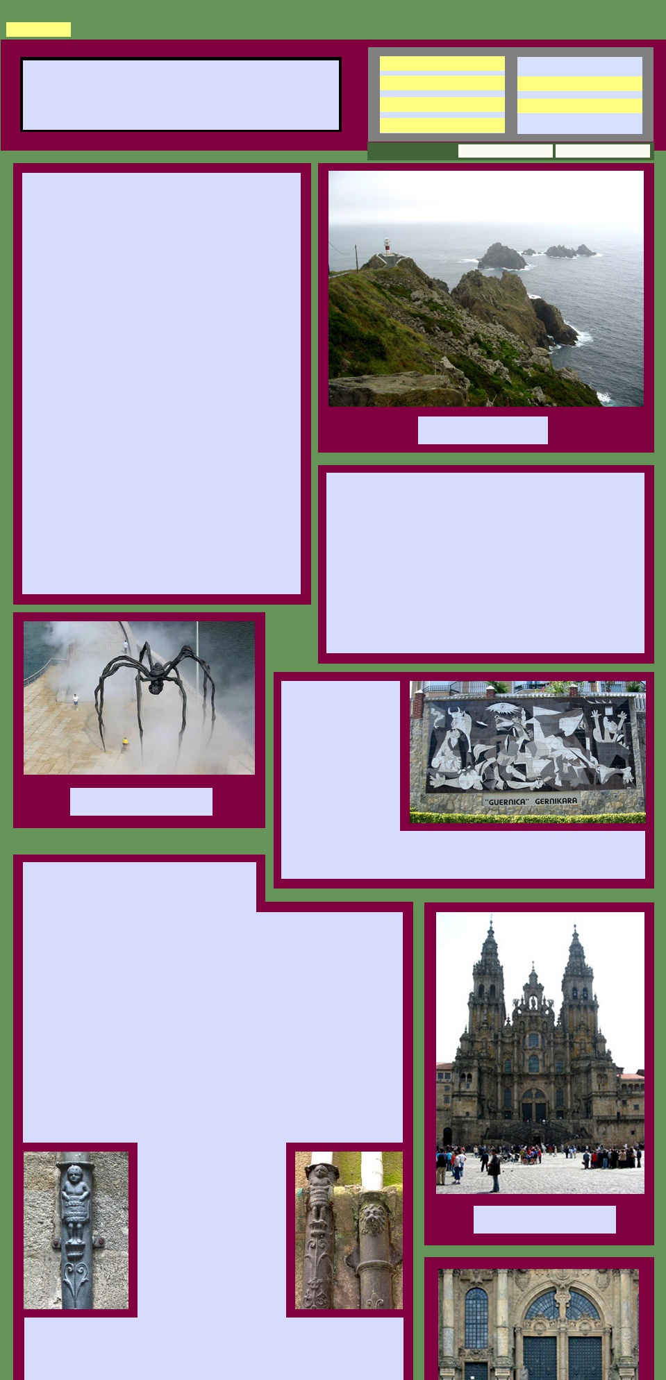
At Cape Ortegal the notion of "end of the earth/world"
reappears. According to Tacitus (some say), it is here that
"heavens, seas and earth end", so making it the End of the
World. It certainly seemed so to us as we emerged from the
mist and found ourselves in the little village San Andres de
Teixido.
Around here we started to see the granaries that are
such a feature of Portugal and north west Spain.
Sometimes constructed in stone, sometimes
wooden slats they are perched on granite stilts.
They are called hórreos around here and are
exceptionally photogenic.
To the north east of La Coruña, the Rias Altas take you into
the wild country of Cabo Ortegal where, if you are lucky
enough to have clear weather you would find yourself in a
small corner of heavily wooded forests where the precipitous
rocky coastline drops into the sea. We drove through here in
cloud so deep that the road ahead was invisible, though we
did see the occasional walking track heading off in the mist.
Around Ferrol there are a number of marked tracks, such as
one leading from Ferrol to San Andres de Teixido.
that you will return in the form of
an insect, a serpent or a lizard
and because of this visitors are
very careful not to tread on these
creatures. Some scholars also
suggest that pagan peoples
believed this was the starting
place for the souls of the dead on
their journey to the Other World.
This is a dramatic place, especially when it is bleak and foggy and big seas crash against the rocks at the base of the steep cliffs. It is not hard to understand why all the myths and legends have flourished.
This is a dramatic place, especially when it is bleak and foggy and big seas crash against the rocks at the base of the steep cliffs. It is not hard to understand why all the myths and legends have flourished.
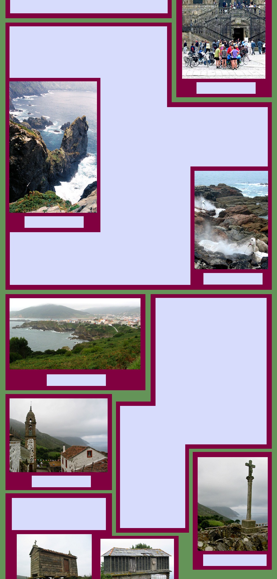
Inland Galicia - the Ribiera Sacra
The owner of a small stylish pension in Castro Caldelas, when
we woke him from his siesta, enquired with some
astonishment how we had found his town. He was happy,
though not entirely satisfied, with the explanation that we
liked quiet, out of the way places and that we planned to
explore the surrounding area and do some walking in the hills
of the Ribiera Sacra.
Castro Caldelas, in the heart of the Ribiera Sacra, is a hidden secret - a mountain top town with a castle and a couple of churches, interesting stately homes emblazoned with coats of arms and a good array of restaurants and bars. The old quarter, above which towers a 14th century castle, is a compact cluster of narrow streets and squares where the houses are often built on the bare rock. Our pension was in the old quarter, nestled under the castle. It ticked all our boxes.
The name Ribera Sacra, or sacred riverbank, comes from the clustering of Romanesque churches and monasteries found round here. The rugged, isolated area attracted hermits and monks who settled here from early Christian times, building the monasteries which became centres of art and culture.
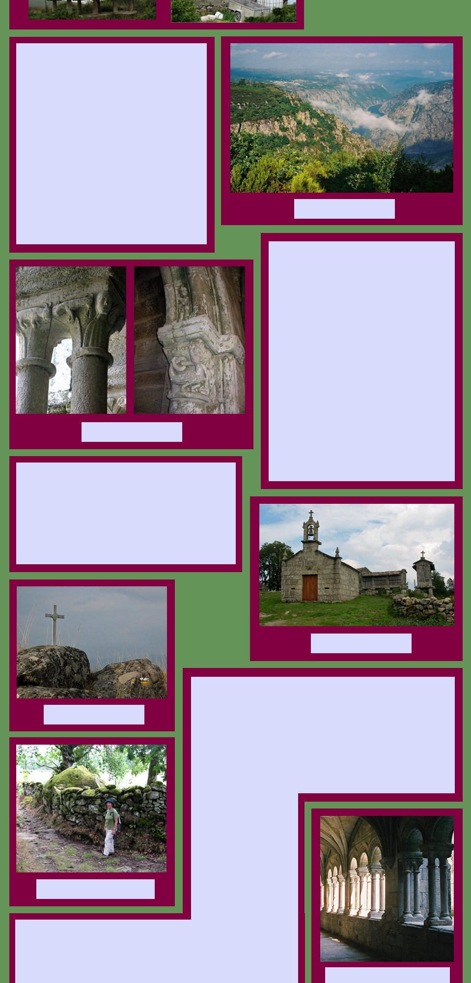
The canyon of the Sil is up to 500 m deep in some places
and along the rim there are numerous natural viewpoints, or
miradors that hang in the sky overlooking the river.
Terraces of vines perch precariously on the improbably steep slopes. Wine production has been carried out here since Roman times when the first terraces were carved out of the rock by slaves. Today wine-making thrives. The combination of native grape varieties, slate and granite soils, and the microclimates of the rivers and their terraces produce excellent growing conditions, for distinctive red wines in particular.
We split our time here visiting some of the monasteries, doing some of the walks in the area and gazing in awe at the view from the miradors. There are some long walks here and many short ones, with good information available from the local tourist office.
The river is the Sil which rises in the Cantabrian mountains
and flows to join the river Miño which then goes on to form
the border between Galicia and Portugal. The geography
here is comprised of high plateaus and mountains with
gentle slopes that give way abruptly to the waters of the Sil.
This is some of the most spectacular gorge scenery in Europe. While the canyons of both the Sil and the Miño are impressive, those of the Sil are steeper, rockier and more inaccessible than the greener, gentler banks of the Miño, which have lent themselves more to human habitation.
This is some of the most spectacular gorge scenery in Europe. While the canyons of both the Sil and the Miño are impressive, those of the Sil are steeper, rockier and more inaccessible than the greener, gentler banks of the Miño, which have lent themselves more to human habitation.
Narrow pathways run between stone walls covered in moss and pass
through villages of stone houses around which cluster the granaries that
are so characteristic of the area. The villages are very neat and well
maintained and the granaries are obviously all very much in use.
Sometimes there is a little church at the centre of the village and
sometimes there will be a cross, a cruciero, to mark the way or provide
inspiration.
It is delightful, easy walking with the occasional frustration of the way markings disappearing but after a while the trusty yellow and white signs reappear and walking instructions, maps and the lay of the land all line up again. Only a minor frustration really.
It is delightful, easy walking with the occasional frustration of the way markings disappearing but after a while the trusty yellow and white signs reappear and walking instructions, maps and the lay of the land all line up again. Only a minor frustration really.
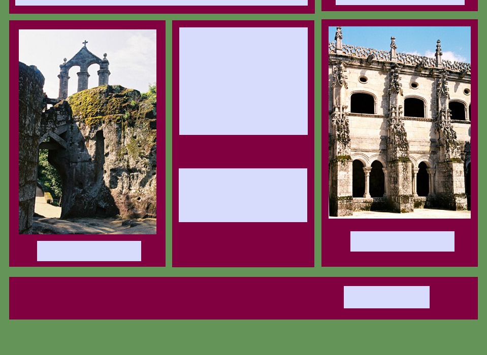
Of the monasteries in the area we visited two - San Esteban de Ribas de Sil and San
Pedro de Rocas.
San Esteban de Ribas de Sil, located to the north of the village of Nogueira de Ramuín is now a state-run Parador, and is reputed to be the largest and one of the best examples of Romanesque Galician architecture. Its setting alone, with spectacular views down to the river make it worth a visit.
References to the monastery's existence can found as far back as the 10th Century, although its origins appear to date back even further, to the 6th and 7th centuries. Inside, various styles can be seen from Romanesque to Baroque, and its three cloisters, all from different periods, are lovely peaceful places. Also of note is its Baroque façade which was added in the 18th Century. The building was declared a historic artistic monument in 1923.
After a twisty drive down a
narrow country road we found
Mosteiro de San Pedro de
Rocas (Monastery of Saint
Peter of the Rock). Although
entry is not allowed into the
Monastery itself, the attraction
here is the church, carved into
the rocks of the mountain hence
the name "of the Rock". It is
believed to be the first hermit
settlement in Galicia, the
presence of the earliest
inhabitants being traced back to
the year 573.
According to the inscriptions on its foundation tablet, which is kept at the Provincial
Archaeological Museum, its founders were seven men who chose this beautiful spot as a
retreat to lead a life of prayer.
We loved this quiet area which seemed
so peaceful and calm. So it was with
terror and alarm that we were blasted
awake one night at 2.30 am by
explosions and flashing bursts of
light.They seemed to be right above, or
even inside, our little pension. After a
few bewildering seconds we realised
that fireworks were being set off from
the castle which was indeed right above
us. A local fiesta, we discovered, which
carried on nearly till dawn.
to Top of Page
Galicia
This simple chapel is small, as churches go, and the rock walls are rough hewn, not smooth
and finished. There were no seats but there were burial places carved into the floor. They are
empty now and slowly wearing away. The place was declared a Historical Artistic Monument
in 1923.
From the Ribiera Sacra our
journey continued into the
Cordillera Cantabrica
and
Los Picos de Europa.
journey continued into the
Cordillera Cantabrica
and
Los Picos de Europa.
Spider sculpture, Guggenheim
Bilbao
Bilbao
Cabo Ortegal
Cathedral at Santiago
de Compostella
de Compostella
At the end of the journey
Cabo Ortegal
Cleaning the Costa da Morte
Sant Andrés de Teixido
Coastline at Sant Andrés de Teixido
Cariño on Cabo Ortegal
Cañon de Sil
Ornamentation
San Estevo de Ribas de Sil
San Estevo de Ribas de Sil
Village church near Castro
Caldelas
Marking the way
Walking on the Rota Noguira-Linares
Cloister, San Estevo de Ribas de Sil
San Estevo de Ribas de Sil
San Pedro de Rocas
Visit FRANCE
Visit ITALY
More of SPAIN/PORTUGAL
Explore on MAPS
Return to HOME PAGE
Explore PHOTO GALLERIES
View pictures of