Cordillera Cantabrica
Los Picos de Europa
Natural parks of the Codillera Cantabrica
There are two natural parks in the south western part of the Cordillera
Cantabrica which are in the process of being jointly listed by UNESCO
to recognise their unspoilt landscapes and ecological and ethnological
importance. The Ancares is a mountainous area which forms a political
and linguistic boundary between the autonomous communities of
Galicia and Castile and León. On the Castile and León side of the sierra
this region is known as Los Ancares; on the Galician side it is Os
Ancares.
The Parque Natural de Somiedo is located in the central area of the Cordillera in the Principality of Asturias and is an area of mountain pastures and glacial lakes.
The Parque Natural de Somiedo is located in the central area of the Cordillera in the Principality of Asturias and is an area of mountain pastures and glacial lakes.
Parque natural de los Ancares
Leaving the Sil you drive through valleys, gorges and mountain passes
to reach the Ancares, an area until recently quite isolated and without
services like electricity.
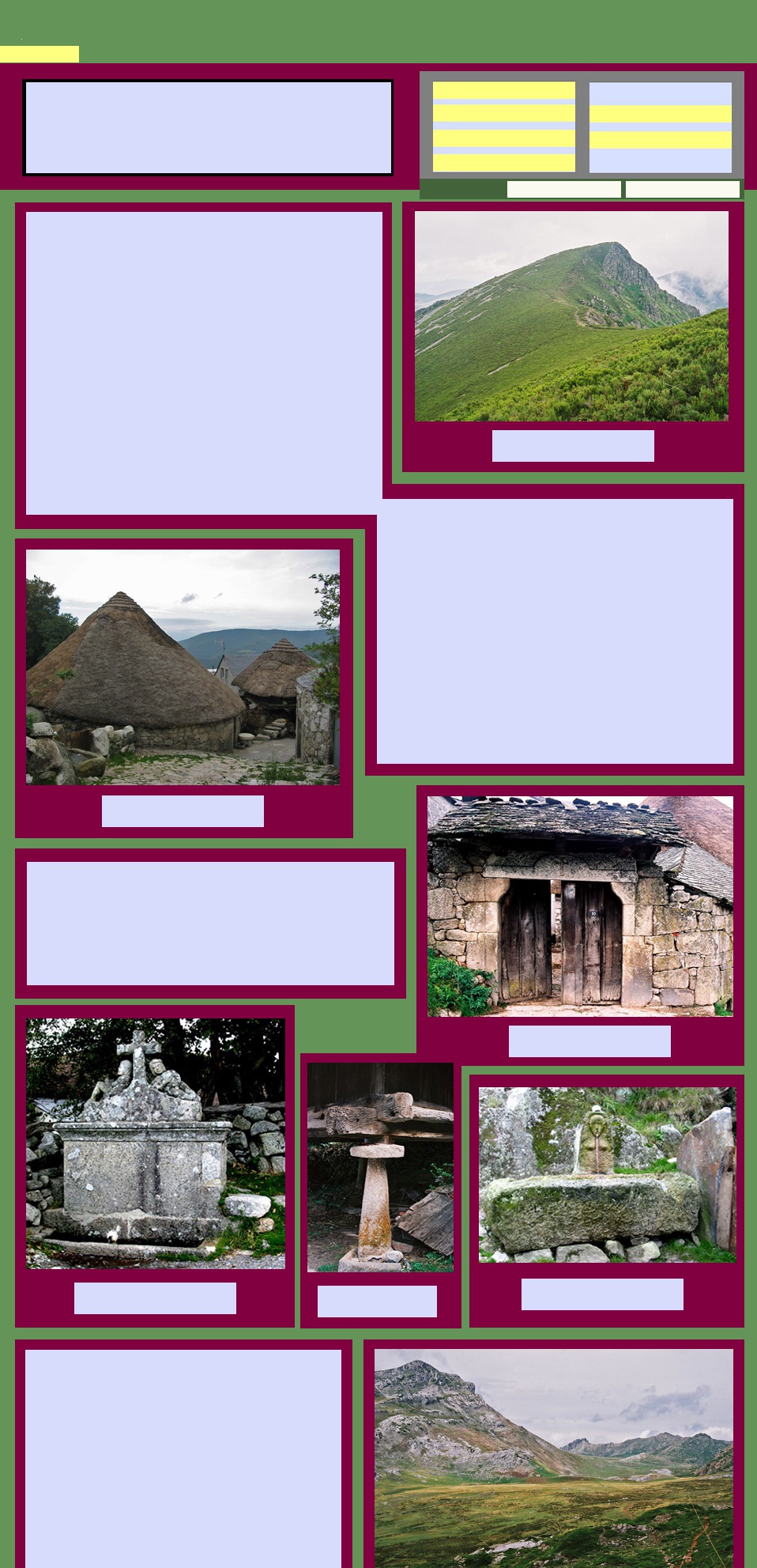
We sought out Piornedo, the most well-known village in the area. Here there are still the stone huts known as pallozas. The style is ancient, 12th century or even hundeds of years earlier.
We sought out Piornedo, the most well-known village in the area. Here there are still the stone huts known as pallozas. The style is ancient, 12th century or even hundeds of years earlier.
The landscape of Piornedo was fascinating. The pallozas are low
circular structures with stone walls and deep pitched roofs of thatch or
slate. They are clustered together in groups, encircled by stone walls
and were obviously designed to retain heat in the severe mountain
winters. The village streets are unsealed and there are water troughs all
about for the animals that roam the streets. Granaries are attached to
most houses, with the under floor area used to store firewood and farm
machinery and perhaps the family car.
There has been quite a lot of money spent in the area to promote tourism and we certainly found no fault with our small rural cantina which was very spick and span and served an excellent evening meal. It was very dark and quiet overnight, the only noise the clinking of cowbells and the barking of dogs. An overwhelming rural aroma filled the air.
There has been quite a lot of money spent in the area to promote tourism and we certainly found no fault with our small rural cantina which was very spick and span and served an excellent evening meal. It was very dark and quiet overnight, the only noise the clinking of cowbells and the barking of dogs. An overwhelming rural aroma filled the air.
The area around is hilly and intensely green with valleys and streams
flanked by spiky limestone peaks. Villages of solid square stone buildings,
with slate or red tiled roofs huddle into the hillsides.
We have never met anyone else who has visited this area, which is a pity as it is so refreshingly different. Although there is not a lot of information about trails available outside the area, it is becoming more popular with walkers. Our hosts in Piorneda provided us with information and we made time to do an exhilarating short walk through the misty hills.
We have never met anyone else who has visited this area, which is a pity as it is so refreshingly different. Although there is not a lot of information about trails available outside the area, it is becoming more popular with walkers. Our hosts in Piorneda provided us with information and we made time to do an exhilarating short walk through the misty hills.
They say that humans and animals lived side by side in these primitive
constructions as recently as ten years ago. Today you pay a token fee to
visit ethnographic museums that have been opened up in these dwellings
by local people.
Parque natural de Somiedo
It is not far from the Ancares, down to the Sil again and then up
into the higher peaks of the Cordillera and the Somiedo Natural
Park. The smart little town of Pola de Somiedo is an excellent
base for more splendid walking. The name Somiedo comes
from the Latin sommetum, meaning "country of high mountains"
and you understand the name when you see the peaks that
form a backdrop to the town.
The tourist office in Pola de Somiedo has good information about the twelve or so fully signed routes that cover the area's lakes and mountains. We chose one of the most popular - a circuit of the mountain lakes which begins from a tiny village reached by a circuitous gravel road. This walk is a stunner - more limestone crags, glacial valleys, vegetation of every hue of green and deep blue lakes.
You could spend some time here, not just walking but also searching for the brown bear. There are fewer than 150 animals living today, split between two isolated populations at either end of the Cordillera Cantábrica. The largest proportion of these are said to be flourishing in the deep valleys and rugged terrain of Somiedo Natural Park. We saw no bears but perhaps we did not devote the necessary time.
The other feature of the area which has contributed to the
UNESCO recognition is the traditional system of transhumance,
using the summer pastures for grazing, known as braña.
Traditional buildings associated with the braña are dotted
around the pasture lands. These are small stone cabins with
steeply thatched roofs which were constructed for shelter and
are now being preserved to ensure continuation of the tradition
and as a tourist attraction.
This area is a well kept secret - not much frequented by time-poor tourists from outside of Spain, but absolutely worth a visit.
This area is a well kept secret - not much frequented by time-poor tourists from outside of Spain, but absolutely worth a visit.
Los Picos de Europa
Los Picos de Europa was Spain's first National Park and is now its
second biggest. Extending to encompass parts of Asturias, Cantabria
and Castilla y Leon it has an area of 646 km ². The northern boundary is
only 15 km from the coast, accounting for the high rainfall and frequent
fog that the mountains experience. They say that the Picos were so
named as they were a welcome sight for European sailors returning into
the Bay of Biscay after their voyages and adventures in the oceans to
the west.
The park is characterised by steep
jagged peaks, marked by the passage
of glaciers and flows of water which
have separated the peaks into three
huge massifs. There are deep caves,
high summits, lakes, gorges and
chasms, overall creating an exciting
mountain environment, popular for a
wide range of activities including caving,
canoeing, climbing and, naturally,
walking.
This is a park where there is a sensitive balance between the environment and the continuation of traditional land management practices. There are no vehicular routes across the park and access is from three towns at its periphy - Cangas de Onis in the north-west, Arenas de Cabrales in the central north and Potes in the east.
Today's park expands upon the original 169 km² of the Parque Nacional de la Montaña de Covadonga, established in 1918 to mark the 12th centenary of the Battle of Covadonga.
Covadonga and the Reconquista
Covadonga is the place where, in 722 AD, a local Visigothic leader called Pelagius or Pelayo led a rebellion against the Muslims and defeated them in the Battle of Covadonga. This was the first time Muslims forces had been beaten in battle and has been commemorated as the beginning of the Reconquista. Pelayo became the first king of Asturias.
Now there is a basilica built on the supposed site of the battle. It contains a shrine in honour of Our Lady of Covadonga, built over a cave where she was said to have appeared to Pelayo and his warriors before the battle. It is a place of pilgrimage where queues of the faithful line up to enter the cave and buy souvenirs.
Cangas de Onis
If first impressions are what counts, our arrival in Cangas de Onis on 12 June 2003 was most propitious. After a wet and misty day driving from the Galician coast, we found an attractive town, buzzing with excitement on the eve of its annual Fiesta de San Antonio, the town's patron saint. There was a bonfire, fireworks and flares lighting up the sky and all the restaurants and sidrerias were busy long into the night.
If first impressions are what counts, our arrival in Cangas de Onis on 12 June 2003 was most propitious. After a wet and misty day driving from the Galician coast, we found an attractive town, buzzing with excitement on the eve of its annual Fiesta de San Antonio, the town's patron saint. There was a bonfire, fireworks and flares lighting up the sky and all the restaurants and sidrerias were busy long into the night.
Next morning we found the residents dressed in traditional costumes,
walking up and down the streets of the town and greeting each other as
the excitement grew. The statue of San Antonio had been brought in
procession from his own small chapel to the parish church of Santa
Maria and now the plaza round the church was the centre of activity while
a mass was being heard. As the mass finished, bells began to ring and
then everyone followed a pipe band through the town. Little children in
gorgeous costumes led the procession, prompted and photographed by
their mothers. The young girls and older women followed, bashing on
castanets and checking out the young men swaggering in their fine gear.
Throughout the procession strong men carried huge cones made of
loaves of fancy bread and decorated with hydrangeas. The centrepiece of
the procession was San Antonio himself, carried aloft on a gold pedestal
surrounded by lilies.
After a few circuits of the
town the saint was carried
back up the hill to his
chapel and everyone split
off for lunch. One of the
jolliest lunches was in the
gardens of a hotel under
the old Puente Romano, a
very fine bridge which is
not actually Roman, but
certainly Medieval.
We had planned to picnic at the popular Covadonga lakes but it was wet and misty and there was nothing to be seen so we returned to Cangas and rejoined the fiesta. Lunch extended into dinner and the partying continued long after we had retired to our hotel. Presumably the late night revellers did not include the hundreds of
We had planned to picnic at the popular Covadonga lakes but it was wet and misty and there was nothing to be seen so we returned to Cangas and rejoined the fiesta. Lunch extended into dinner and the partying continued long after we had retired to our hotel. Presumably the late night revellers did not include the hundreds of
participants in a cycle race that departed from outside our hotel at 9.00
next morning.
We left soon afterwards and as we drove along the northern side of the Picos, the clouds lifted and the mountains started to appear. We resolved then and there to come back, in September the following year, when the weather would, we hoped, be more conducive to walking in the mountains.
We left soon afterwards and as we drove along the northern side of the Picos, the clouds lifted and the mountains started to appear. We resolved then and there to come back, in September the following year, when the weather would, we hoped, be more conducive to walking in the mountains.
A Base in Basieda
On our return to los Picos we based ourselves for a fortnight in Basieda, a very small village not far from Potes on the eastern side of the massif. We revisited Cangas de Onis, still agreeable but missing the buzz of the previous year's fiesta.
On our return to los Picos we based ourselves for a fortnight in Basieda, a very small village not far from Potes on the eastern side of the massif. We revisited Cangas de Onis, still agreeable but missing the buzz of the previous year's fiesta.
We had chosen to stay in this area, known as the Liébana, because of its proximity to the
mountains and because its capital, Potes, is a busy market town where we could find all the
necessaries. The Liébana is characterised by its location in a geological bowl enclosed by
mountains on all four sides and with four verdant valleys converging at Potes. Basieda, where
we had found an apartment, is a small hamlet about 10km to the south east.
At Basieda we settled into the very comfortable apartment with wonderful views over an often misty valley towards more craggy mountains. From here we made excursions to do two of the most exhilarating walks that Spain can offer. We also enjoyed visiting Potes, exploring the Liébana and making an expedition into the area known as the Palentino Románico where an incredibly rich concentration of Romanesque churches is found.
At Basieda we settled into the very comfortable apartment with wonderful views over an often misty valley towards more craggy mountains. From here we made excursions to do two of the most exhilarating walks that Spain can offer. We also enjoyed visiting Potes, exploring the Liébana and making an expedition into the area known as the Palentino Románico where an incredibly rich concentration of Romanesque churches is found.
long defile carved through the limestone by the River Sella. The river rushes at the base of the
defile and on each side of the road rise up eerie, spiky peaks that look like the sinister places
that witches and wizards would live.
A route south
and east of
Cangas brought
us, through the
Desfiladero de
los Beyos to
Potes. The
desfiladero is an
amazing 10 km
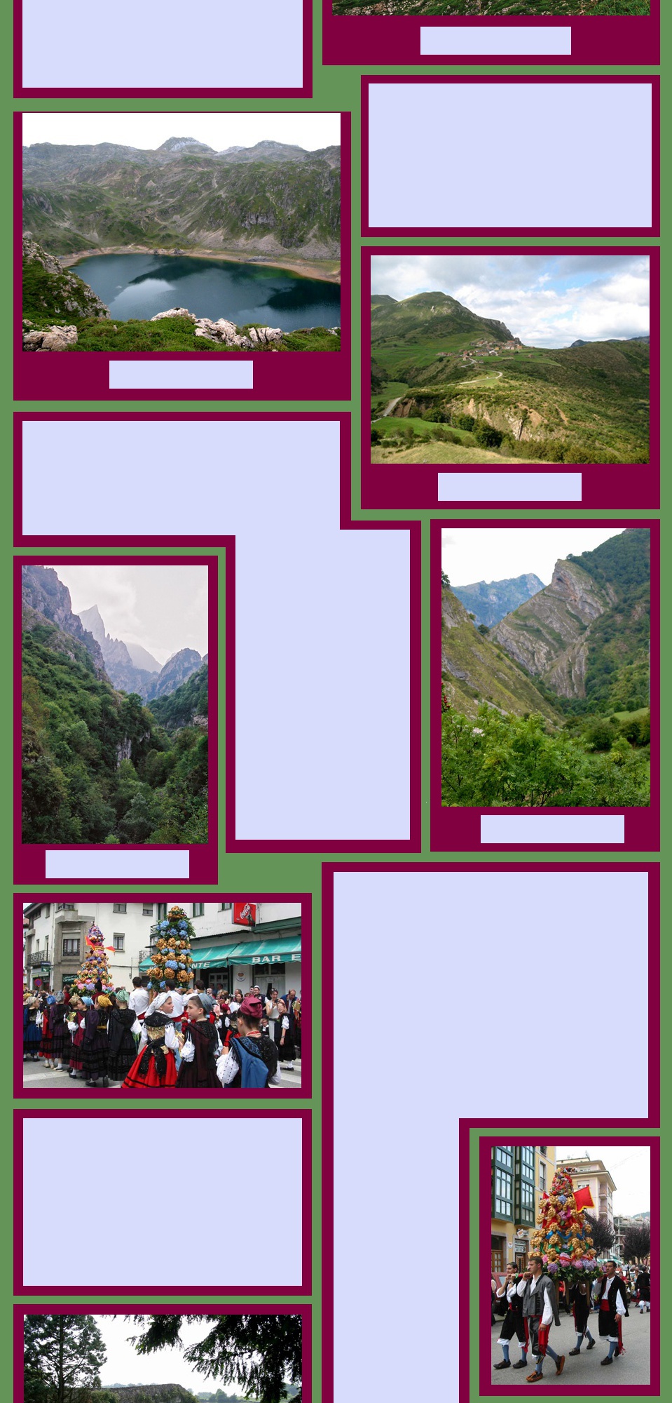
Walking from Fuente Dé
A short drive from Potes brings you to Fuente Dé and El Cable, a teleferique that deposits its passengers about 900 m up onto the massif where there are a number of options for walking or climbing. Having anticipated walking here for so long, we decided to give this a go early in our stay. But even the best laid plans couldn't control the weather and we arrived at the top of El Cable in thick cloud.
Persevering in spite of the cloud, we set out on a rocky pathway along the rolling plateau till we reached the Refugio de Aliva where hot coffee warmed us up and we saw that the cloud was beginning to lift. From here the walk was a wonderful downhill stroll on a wide trail between the peaks where the mist was still swirling around. Incredibly green pastures were being enjoyed by mountain cattle and gorgeous long haired sheep. From time to time we passed a cluster of uninhabited stone shelters which looked pretty bleak.
In the valley, Espinama is a pretty village with
lots of options for cold drinks and from there a
steep track took us back up to Fuente Dé.
There were more little villages along this
route, rustic rural scenes and fabulous views
of the mountains.
Two days later beautiful clear blue skies tempted us back up again and the scene could not have been more different. The sun shone down, the peaks stood hard-edged against the brilliant sky and there were walkers and climbers everywhere. The long horned cattle and woolly sheep were still eating grass and watching the world go by.
This time we didn't go down to Espinama but took a northerly route that climbed up slopes of scree between great lumps of rock where no vegetation grew and if you kept going you would reach some of the highest peaks in the Picos. But we weren't into heroics and after a while returned to El Cable and down to Fuente Dé.
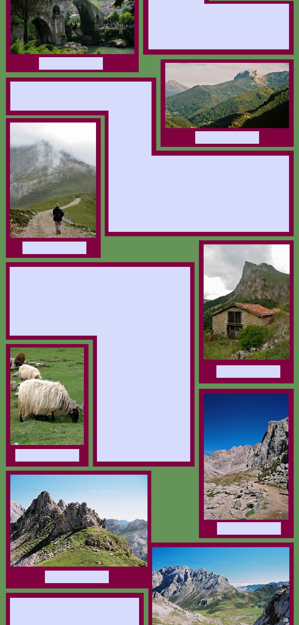
Garganta del Cares
This is the walk that everyone comes to the Picos to do so it is always pretty busy. But what a walk!
A spectacular ravine, gouged through the limestone by the river Cares, runs north/south between the central and western massifs of the Picos. In the years between 1916 and 1925 the river was partially diverted towards a hydro- electricity plant at a little place called Poncebos. To facilitate the project, a canal and a pathway to service it were hewn into the rocky cliffs above the river. Today's walk follows this pathway.
You can do the walk from either end but it is usually recommended to start at the northern end and save the best parts till the end.
The route is 12 km from end to end. You do the hardest part at
the beginning - a steady uphill climb for about 3 km, passing
some abandoned buildings and the occasional opportunistic drink
seller. Once over the highest point you see the track ahead,
winding along the gorge and hugging the cliff edge. It is simply
stunning but perhaps not a walk for those who fear heights.
From time to time the track passes through tunnels cut out of the rock. The canal cuts through tunnels too, sometimes running alongside the path so you can have a refreshing cool down. Wierd rocky formations stand alongside the path and you look up to natural archways and crevaces in the limestone.
Approaching Cain, the track comes down to the level of the river which is a dark blue limestone green. It is moister down here and vegetation, not seen on the higher parts of the gorge, clings to the valley walls. The path crosses the river twice on spectacular bridges, and eventually reaches a series of very wet galleries which you feel your way through to emerge in grassy meadows and the town of Cain.
We picnicked by the river, in the company of a large group of French walkers who were enjoying a marvelous spread they had laid out on the grass. It was a Sunday and lots of Spanish families were also enjoying a day's walk in the gorge on what was a hot day for mid September. Eventually we all set out to return the same way, finding the return trip in the opposite direction just as spectacular.
Romanesque Churches of the Palentino Románico
and the Liébana Valley
While staying at Basieda we made several excursions to seek out some of the many Romanesque churches in the area.
The Romanesque style (Romanicó in Spanish) was the dominant architectural style in Europe in the 11th and 12th centuries, continuing well into the 1200s, when it was gradually replaced by the Gothic.
The main characteristics of the style are thick and heavy walls, barrel vaults, small windows, round arches supporting the roof and, overall, simplicity and harmonious proportions. Romanesque churches were the first buildings to incorporate monumental sculpture since ancient Rome. But not all the church art is religious: many carvings and paintings depict plants, animals, mythical beasts, pagan imagery, scenes of daily medieval life, and humorous figures.
Between the 10th and 13th centuries, the new
building techniques had reached Iberia, through
travellers and craftsmen travelling along the
Way of Saint James. These techniques were
rapidly adopted in the construction of monasteries and churches, enriched by existing traditions,
particularly the continuing presence of Muslim art.
The Palentina Románico has the greatest concentration of Romanesque churches and shrines in Europe. There are also many outstanding examples in the Liébana valley. There are so many that it is not possible to see them all in a couple of days but we were most interested in the tiny churches that are found in really small villages.
We would find these little gems in almost deserted villages where there were no shops or cafes, but just a trickle of enthusiasts following the routes offered by the local tourism offices. Occasionally the churches were open, sometimes you could get a key from a local resident but more often we had to be satisfied with a look around the outside. But for all but the real experts this is usually enough to give an appreciation of the beautiful simplicity of the structures, their superb exterior decoration and the history that speaks from such ancient stonework.
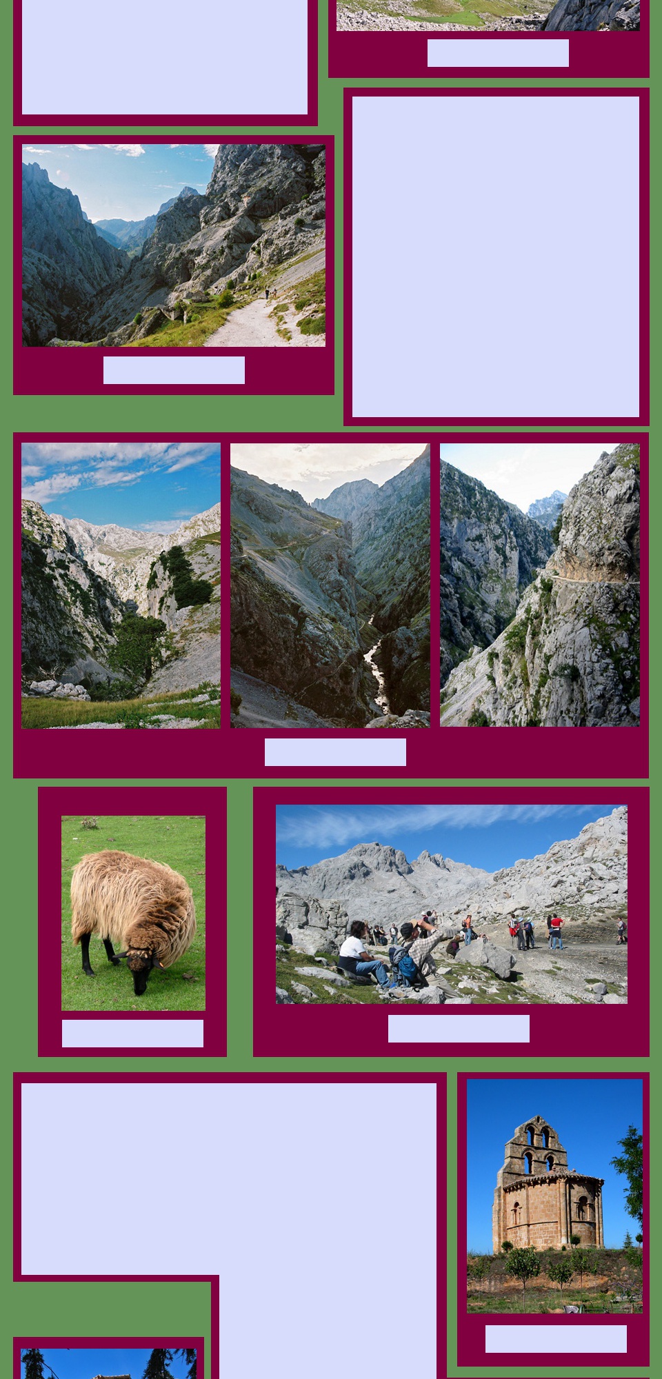
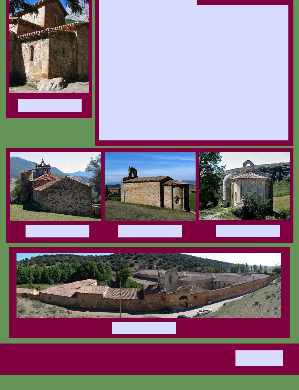
Our favourites in the Palentina Románico were the Monastery of San Andres de
Arroyo built in the 12th and 13th centuries and still a working convent, the tiny Shrine
of Santa Cecilia de Vallespinoso de Aguila, standing on a rocky outcrop in the
countryside and the elegant 12th century Ermita de Santa Eulalia on a hill outside
Barrio de Sta Maria.
From the 8th century onwards the Palentina
Montaña area around Aguilar do Campoo
and the Liébana valley around Potes were at
the forefront of the reconquista. Christians
were settling in this isolated country to
reestablish their religion. Some hermitages
are known to date from those first
settlements.
Nearer to home was the superb 10th century Santa Maria de Liebana incorporating
horseshoe arches from pre-Romanesque times and the local church at Basieda
which was just up the hill from our apartment. One of the prettiest, whose name we
never knew, was by the roadside as we left the area driving towards Burgos. Pictures
of all these and the others that we discovered are in the photo gallery.
return to Top of Page
On road to Burgos
Santa Maria de Liebana
Local church at Basieda
Ermita de Santa Eulalia
Santa Cecilia de Vallespinoso
San Andres de Arroyo
Woolly mountain sheep
Start of a fine day's walking
Walking track near Piomedo
Pallozas in Piomedo
Doorway in Piomedo
Water fountain, ca 1725
Piomeda
Piomeda
Wood and stone
Piomeda
Piomeda
Drinking trough, Piomeda
In the Parque natural de Somiedo
Glacial lake, Somiedo
Road through the Puerto de
Somiedo
Desfiladero de los Beyos
Towards the Picos de Europa
'Roman' bridge, Cangas de Onis
Mountain view from our terrace,
Basieda
Basieda
Walking in the clouds
Mountain refuge, los Picos
Mountain sheep
Track to the highest peaks
Peaks near Fuente Dé
Track across the plateau,
Fuente Dé
Fuente Dé
Entering the Caries Gorge
Through the Caries Gorge
Visit FRANCE
Visit ITALY
More of SPAIN/PORTUGAL
Explore on MAPS
Return to HOME PAGE
Explore PHOTO GALLERIES
View pictures of