The Volcanoes of
the Massif Central
Almost in the centre of France, straddling the
départments of Puy-de-Dôme and Cantal is a wild
landscape of extinct volcanoes contained within
Le Parc Naturel Régional des Volcans
d'Auvergne.
Here there are strangely shaped mountains, deep
crater lakes, green upland meadows,
Romanesque churches, whimsical castles and
quaint, dark stoned towns and villages. There are
old spa towns and newly developed ski resorts,
though these are less popular and fashionable
than the celebrated resorts of the alps and
Pyrenees as they do not receive such reliable
snow. There is also some excellent walking and if
you are lucky you may encounter better weather
than is often the norm.
We spent some time here in September 1995 in weather which was declared by
the local people to be "pas normal". Maybe the misty cloud, rain and cold
temperatures that year were a bit abnormal for early autumn but this area is
famous for its luscious green countryside and rich pastures these certainly don't
indicate a dry climate.
Leaving Lyons and driving south towards a gîte in the Cantal we stopped first for
a few days in Murol to explore the area of the Monts Dore. An imposing chateau,
floodlit at night, towers over the town and, during the season, you can take a
tour with a group of actors who give lively re-enactments of life in a mediaeval
castle.
Cheese
This is cheese country - St Nectaire, Blue d'Auvergne, Forme
d'Ambert and huge rounds of Cantal - all made on the farm, oozing
with flavour, and totally different products to the bland and pasteurised
versions that are imported into Australia under the same names.
Instinctively then, exploration here started with a circular walk through
the countryside, taking in St Nectaire and returning via the castle.
Strangely, St Nectaire is the only town in the region where they don't
make the St Nectaire, though its simple and beautifully proportioned
Romanesque church is well worth a visit.
Around le Mont Dore
Le Mont Dore is a spa town sprawling along the banks of a
babbling little stream which turns out to be the upper
reaches of the Dordogne. From le Mont Dore you can walk,
or take a cable car, up to the slopes of Puy de Sancy and
then follow a variety of tracks around the mountains.
Nearby is the very deep and mysterious Lac Pavin which
is circumnavigated by a walking track. You can follow
the track all the way around while pondering the deeply
mysterious legends about the lake that have been told
over time.
It is hard to imagine that the benign countryside of the
Auvergne was once a landscape of more than 100 active
volcanoes. The huge upheavals of the earth that threw up the
Alps and the Pyrenées weakened the granite plateau of the
Massif Central. From these fissures and weak points molten
material was able to burst through in the eruptions that
created the volcanoes of the Chaîne des Dômes in the
Clermont Ferrand area and those of the Monts Dore and the
Cantal.
Afterwards, the ice ages gradually wore down the
landscapes and many thousands of years of erosion by
wind and water followed. Vulcanologists tell us that the
peaks of the Cantal - Puy Mary, Puy Violent, Puy Griou and
Plomb de Cantal - are in fact the remains of one huge
volcano which was about 100 km around its base and over
3000m high before geological time and nature took their
course.
The Gîte at Aris
Our gîte was in the hamlet of Aris, a few km up in the hills above the
market town of Vic-sur-Cère which is 21 km from the much larger
regional town of Aurillac. This was a comfortable small house which
had fairly recently been split from a larger complex of farm buildings.
It was fairly clear that the proprietor, who lived in Aurillac, had only
recently acquired the gîte from the owners of the farm, perhaps as a
hobby or business venture. She was a townswoman with a young
family and didn't seem to have the shrewd savvy of the usual gîte
owners. Despite the sale of the gîte, the farming continued all around
us with the coming and going of tractors and long lines of cattle
meandering along the road at milking time.
We were thrilled to discover that we had our very own vegie garden
and orchard. The last pickings of a crop of beans and carrots and
some herbs and parsley were ours and the apple and pear trees in
the orchard still had some fruit.
We had the choice of two villages for shopping. Polminac
was closest for meat, bread and patisseries and basic
groceries; Vic-sur-Cère was a little further down the
valley with proper supermarkets and a market on
Tuesdays with the usual mobile charcuteries,
boucheries, fromageries, truiteries and a good selection
of local fresh produce. It also had a range of proper
shops which was to prove useful in the quest for warmer
clothes to ward off the "pas normal" weather.
The major towns and villages run along the valley of the
Cère and on either side are steep hillsides dotted with
farms, hamlets like Aris and, occasionally, a castle. The
valley sides become progressively steeper as you climb
towards the resorts of le Lioran and Super-Lioran which
nestle in the valley between the volcanic peaks of Puy
Griou and Plomb de Cantal.
Walking and Exploring
There was a wide choice of local walks which climbed up
into the rocky hills and opened up to views up and down
the valley. We did these while waiting for some clear
days to take on the higher peaks. The serious walking
was from le Lioran and Super Lioran where, after a few
aborted attempts our patience was rewarded and we
struck a glorious day, albeit very wind, but with cloudless
clear skies rather than the rain, mist and complete lack
of visibility.
After climbing gradually for a couple of hours we
reached the uplands, studded with peaks with enticing
names like Bek d'Aigle, Téton de Venus and Puy Griou
and with wonderful views that took in all the mountains
of the Cantal. After all the climbing we picnicked in a
sheltered spot before an easy downhill walk which
finished along the groomed ski runs of le Lioran.
Across the valley is the big lumpy Plomb de Cantal
which, at 1855m, is the highest peak in the Cantal. You
can take a télépherique to the summit and then walk
out along the GR 4 or the myriad of other trails up
there. This is really exposed country and is only worth
doing in good weather.
Running roughly north east from Aurillac is the spectacular road
called the Route des Crétes which takes you up to the Pas de
Peyrol and Puy Mary. Puy Mary and the quaintly named Puy de
Peyre Arse are the most northern of the peaks that remained after
the eruption of the ancient volcano. Here we took the track up to the
summit of Puy Mary where there is a vast panorama and a table
d'orientation which helps put the whole area into perspective.
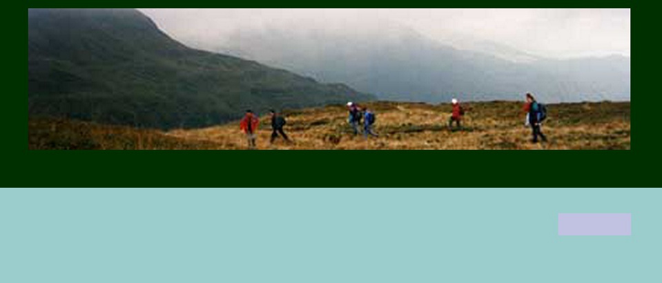
The climb up to the summit was in dense cloud but, as we
continued on a track running along the high crests, the cloud broke
up to consecutively reveal wonderful views and then bank up in
huge threatening swirls around the peaks. This was all pretty
dramatic and we took it all in for hours until retreat from rather
more serious clouds seemed wise and we made it back to a
cheery bar at the pass just as a true deluge began.
Round trips by car in this area can take in the walled mediaeval
town of Salers, famous for its cattle - big red beasties with rough
hairy coats and huge lyre-shaped horns - and its annual cattle
fair. Around here they are used to Australians as many
cattlemen come to the fair every year and compare notes with
the original breeders of these beasts that have now become quite
popular in Australia.
Other trips to the south can take in the Truyere gorges and to the
west can pick up the Allier and much of the route of the GR 65 as
far as Le Puy. Vic-sur-Cère is very well placed for a variety of
experiences, so if "pas normal" weather strikes there is still lots to
do.
Place Names
The curious place names that occur time and time
again eventually have you searching for their meaning.
Some explanations are
• Puy, Dôme, or even Puy de Dôme - a volcano or
volcanic peak.
• Super, as in Super-Lioran, Super-Besse - signifies that there is one town without the prefix, eg le Lioran, and another higher up the mountains which gets the Super tag.
• Téton, as in Téton de Venus - a familiar word for a breast which is usually ascribed to mountain peaks which jut up in the shape of a breast. Sometimes they even have nipples.
• Chaos - a jumble of rocks
Return to Top
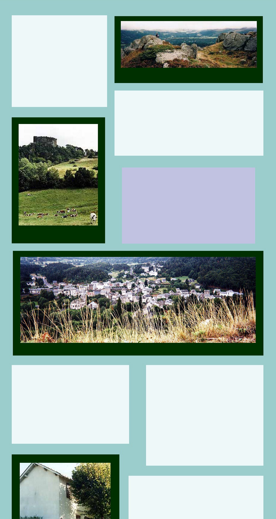
Looking towards the extinct volcanoes
Murol Castle
The spa town of le Mont Dore
The Gîte at Aris
Farmland near Aris
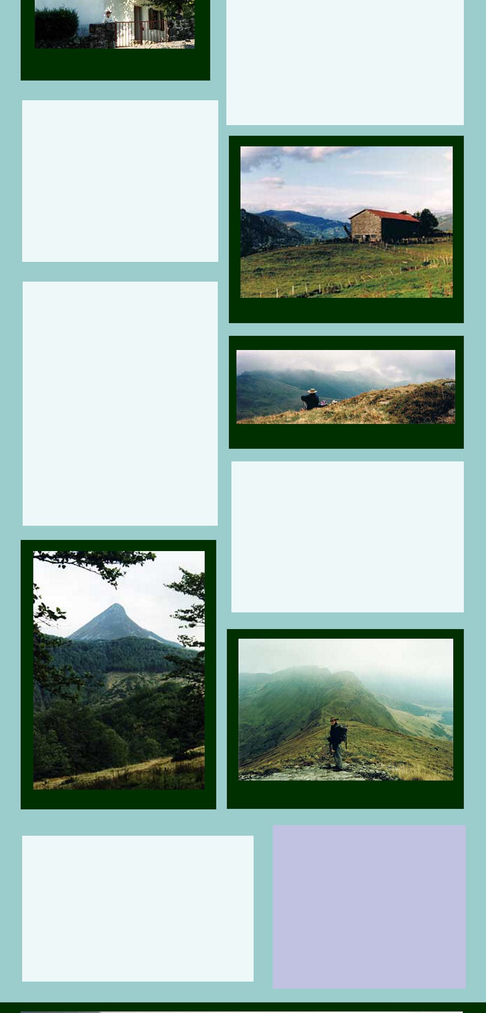
Walking round le Lioran
View of Puy Griou
Walking up Puy Mary
Explore more FRANCE
Visit ITALY
Visit SPAIN/PORTUGAL
Explore on MAPS
Return to HOME PAGE
Explore PHOTO GALLERIES